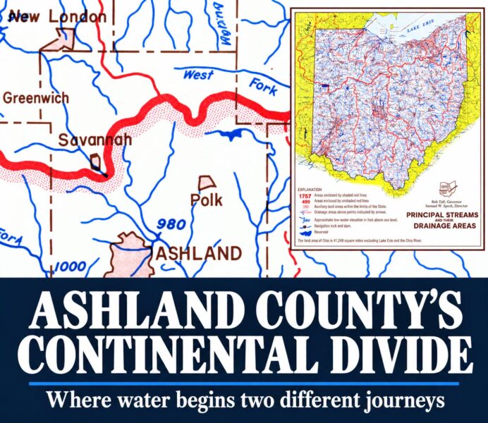

An Invisible Line Through Ashland County Sends Water Toward Two Different Destinations
ASHLAND COUNTY, Ohio — Rain falling across Ashland County can begin two very different journeys. Some runoff heads north toward Lake Erie and the St. Lawrence River. Much of the rest enters streams connected to the Mohican River, eventually reaching the Ohio and Mississippi rivers.
The difference comes down to an easily overlooked feature of the local landscape: a continental drainage divide running through northern Ashland County.
Ashland County’s comprehensive plan, approved in February 2000, identifies the boundary as the separation between the Great Lakes and Ohio River drainage basins. The plan places the county’s northern tier within the Lake Erie basin and describes most of the county as part of the Mohican River watershed.
Unlike a county line, this boundary follows the shape of the land. Hills and ridges separate neighboring watersheds, directing surface runoff toward different stream systems. The U.S. Geological Survey calls those boundaries drainage divides. A watershed includes the land draining toward a common outlet, along with its connected streams, lakes and wetlands.
For Ashland County residents, that means a small change in where rain lands can put runoff into an entirely different river network.
Clear Creek Township provides a local clue
One specific township reference appears in an account published well before modern digital watershed maps.
Norman Newton Hill’s 1880 History of Richland County, Ohio, reproduced on the Ashland County OHGenWeb website, describes the center of Clear Creek Township as the dividing ridge between the headwaters of the Mohican and Vermilion rivers.
The historical account also identifies Savannah Lake, near the township’s eastern center in Sections 13 and 14, as a source of the Vermilion River. The description provides a documented local connection between the divide, Clear Creek Township and the Savannah area. It should be read as a historical geographic description rather than a precise survey of today’s watershed boundary. ashland.ohgenweb.org
Local writer Irv Oslin likewise identifies northern Ashland County as a place where the Lake Erie and Ohio River watersheds meet. His guide to Mohican Country geography explains that the county’s divide is one of the continent’s drainage boundaries, distinct from the better-known divide associated with the Rocky Mountains.
The northern route: Lake Erie and the St. Lawrence
The Lake Erie side of Ashland County includes portions of the Vermilion and Black river watersheds. Ohio EPA maintains watershed assessments covering both systems and identifies Ashland County within their drainage areas.
The Black River offers a clear example of that northern connection.
According to Lorain County’s watershed information, the Black River’s West Branch begins in northern Ashland County and continues into Lorain County through Rochester, Wellington and Oberlin. It joins the East Branch in Elyria. The combined river then continues north and empties into Lake Erie at Lorain. Lorain County, OH
Once water enters Lake Erie, the Great Lakes’ downstream connection leads through the Niagara River, over Niagara Falls and into Lake Ontario, then through the St. Lawrence River toward the Atlantic. NOAA describes that sequence as part of the connected Great Lakes system.
The southern route: Mohican, Muskingum, Ohio and Mississippi
Across much of Ashland County, runoff enters the Mohican River system.
That network includes familiar local waterways such as Jerome Fork, Muddy Fork, Black Fork and Clear Fork. Oslin’s geographic guide explains that Jerome Fork and Muddy Fork join to form Lake Fork upstream of Mohicanville Dam. Black Fork and Clear Fork meet south of Loudonville to form the main stem of the Mohican River, with Lake Fork joining farther downstream.
The Mohican then joins the Kokosing River to form the Walhonding River. At Coshocton, the Walhonding and Tuscarawas rivers combine to form the Muskingum River. From there, water continues into the Ohio River, then the Mississippi River and ultimately the Gulf of Mexico.
The two routes help explain why neighboring communities can share a county government, road system and school connections while belonging to different drainage basins.
Finding the boundary on the ground
The divide is a boundary governing surface drainage. It does not mean every stream on one side flows directly north or every stream on the other flows directly south. Streams follow local slopes and can turn repeatedly before reaching a larger river.
USGS maintains a national Watershed Boundary Dataset showing drainage areas defined by the terrain. The agency recommends its National Map Viewer for displaying and creating watershed maps. Those resources are more suitable for checking a particular property or road crossing than a general description of northern Ashland County.
The sources reviewed for this story establish the divide’s presence in northern Ashland County and provide the historical Clear Creek Township reference. They do not establish an exact, verified U.S. Route 42 intersection. A precise crossing should therefore be checked against watershed mapping before being identified in a published road guide.
The drainage boundary also should not be treated as a fixed weather boundary. Its geographic meaning concerns where surface water drains; that alone does not establish where rain, snow or changing road conditions will occur.
Why the divide matters beyond geography
Understanding the watershed connection helps explain why local soil and water conservation work can have effects beyond county borders.
Ashland County’s 2000 comprehensive plan identified sediment runoff from construction, residential development and farmland as water-quality concerns. Those findings are historical planning information, rather than a current assessment of individual streams, but they show that the county has long recognized the connection between land use and downstream water conditions.
That work continues locally. In a May 2026 announcement, Ashland Soil and Water Conservation District highlighted cover crops as a way for farms to protect soil and manage water. The district also described a conservation program featuring Twin Oaks Farm and its experience with cover crops.
An earlier district announcement documented Muskingum Watershed Conservancy District funding for a cover crop interseeder intended to reduce erosion on Ashland County cropland. It is one example of local conservation work tied directly to the larger watershed.
For residents, the divide offers a different way to look at a familiar landscape. A roadside ditch or small creek is the beginning of a much larger connection. In northern Ashland County, the land determines whether that connection leads toward Lake Erie or into the river system stretching south through the heart of the country.